Very demanding route (the use of hands, wire ropes and rungs is necessary to make progress, the use of a helmet is also recommended, as well as a climbing belt and a self-belay kit. The route may lead across steep snowfields, where ice picks and crampons are required)
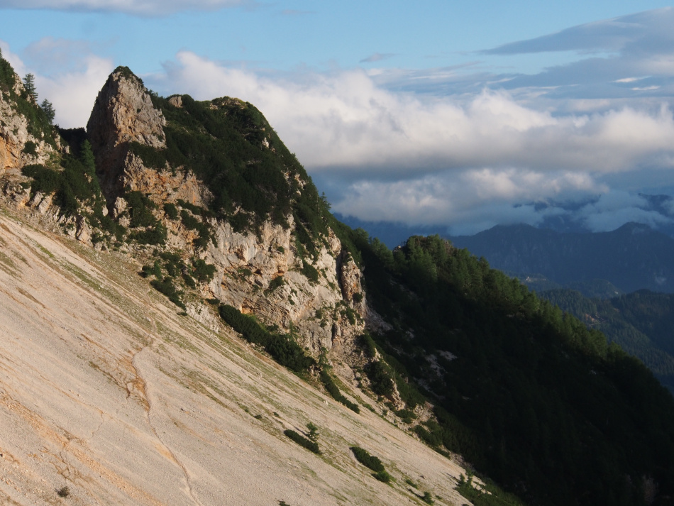
| Vratca (1802 m)
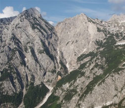
Vratca - the top of the northern ridge of Kočna, which divides the Makekova and Ravenska kočna valleys - is the 'house view' of the Češka koča mountain hut..
More
|
Vratca offers a unique view of both the valleys beneath and the mighty western wall of Kočna. In mid-summer in the steep gully beneath the summit, rare edelweiss found in this area are known to peek out, whilst when crossing the western side you could be lucky to glimpse the chamois that reign in the vast, unchartered area from Vratca to Veliki vrh where there are no paths.
Trail - From Češka koča hut ascend to where the path branches off above Kampeljc (the largest boulder on the scree of Spodnje Ravni) and continue to the right across scree to the entrance to a gully between Vratca and Zeleni kup. Ascend the gully, which is full of loose rock, thus there are aids to assist here and there, to the ridge and take a final few steps through scrub to the peak where there is a box containing a visitors' book and stamp. Descend on the same path. (Source: Jezerska Mountain Path. Guide and diary. PD Jezersko, Jezersko, 2018) |
|
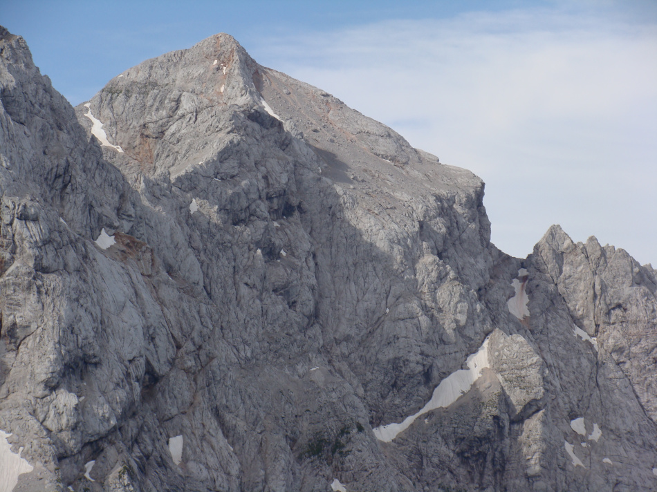
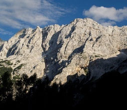
| Kočna (2540 m)
Kočna (originally known as Kljuka) is Jezersko's mountain; seen at its most magnificent from the Makekova kočna valley, where it is only accessible to chamois and alpinists as there are no marked paths.
More
|
It is only possible to walk to the foot of the former highest waterfall in Slovenia – Čedca - which in 2008 collapsed and just a couple of cascades of the 130 metre-high waterfall remain. The peak has also preserved its original wildness – although the path across scree above the precipitous walls looks safe, caution is required. The picturesque shaft beneath the summit will have you on all fours, whilst at the end awaits the lightning-struck stoney summit which inclines above the abyss of the western wall. The ascent to Kočna is a true mountaineering adventure, and to make it even 'sweeter', the descent to Zgornje Ravni offers one of the most beautiful areas of scree in the Kamnik-Savinja Alps.
Trail - From Češka koča hut, cross the scree of Spodnje and Zgornje Ravni, where the paths to the Mlinarsko sedlo saddle (left) and Kočna (right) split and ascend to the entrance to the eastern wall of Kočna. Climb the protected path to the northern ridge of Kočna and continue to the intersection of paths above the Dolška škrbina ridge. The majority of the time the path is exposed and in places covered with loose stones, therefore a helmet and caution are required. Rucksacks can be left at the intersection so that they won't be a hindrance when climbing through the shaft. After conquering this infamous section, just an easier section of scree and some climbing awaits along the lightning-struck tattered peak of Kočna. From the peak descend back to the intersection, from where you can continue to descend on the same path as per the ascent, or continue to descend along the picturesque Dolška škrbina ridge and then from the bottom of the ridge ascend to Grintovčeva streha and on to the summit of Grintovec. (Source: Jezerska Mountain Path. Guide and diary. PD Jezersko, Jezersko, 2018)
(From Češka hut) |
|
|
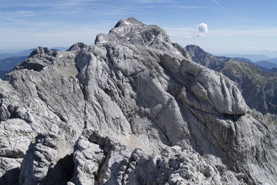
| Grintovec (2558 m)
Grintovec is the highest peak of the Kamnik-Savinja Alps, after which the wider group of peaks is known, the so-called Grintovci. The origin of the name probably derives from "grintav" (meaning furrowed, wrinkled, frail).
More
|
When seen from the Jezersko valley, its magnificence cannot compare to Kočna; from the southern side, sheep even graze all the way up to the top, somewhat diminishing its grandeur. Nonetheless, it is a beautiful viewpoint. On the top, there is an orientation table that shows the surrounding views. In early spring, when snow conditions are favourable, the southern side offers great opportunities for ski touring on Grintovčeva streha (Grintovec's roof).
Trail - Starting from Češka koča mountain hut, passing through the scree fields of Spodnje and Zgornje Ravni, where the paths splits towards Kočna (to the right) and Mlinarsko sedlo, Dolgi hrbet, and Grintovec (to the left), and ascend to the entry point of the northern walls of Grintovec. Following the secured Frischaufova pot (Frischauf's path; due to popularity of this path, wearing a helmet is highly recommended at least in this section, and in early summer an ice axe might also be necessary), continue to the Mlinarsko sedlo saddle. From the saddle, turn right along the ridge, passing over Mali Grintovec to Grintovčeva streha. Here, the path merges with the one coming from Kočna over the Dolška škrbina ridge, continue along the ridge to the summit. Descend following the same route, or optionally continue to Kočna or to the Cojzova koča mountain hut on the Kokrsko sedlo saddle. (Source: Jezerska Mountain Path. Guide and diary. PD Jezersko, Jezersko, 2018)
|
|
|
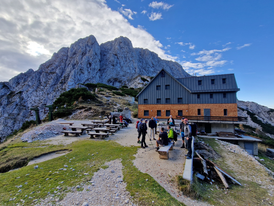
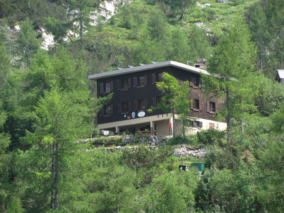
| Cojzova koča hut on Kokrško saddle (1791 m)
The Cojzova koča mountain hut stands on the Kokrsko sedlo saddle between Grintovec and Kalška gora.
More
|
The saddle is also the pass between the Kamniška Bistrica and Kokra valleys. It is named after the brothers Žiga and Karl Zois. The original hut was built in 1897, then in 2022 it was last renovated and enlarged to its current form.
Trail -From the top of Grintovec descend on an easy path across Grintovčeva streha and at the bottom turn left at the intersection of paths towards Kokrsko sedlo and onwards to Cojzova koča. Return on the path across Veliki podi past the bivouac beneath Grintovec to the Mlinarsko sedlo saddle. From here descend on the Frischaufova pot path to Zgornje Ravni and continue across scree downwards to reach the Češka koča hut. (Source: Jezerska Mountain Path. Guide and diary. PD Jezersko, Jezersko, 2018)
(From the tof of Grinovec)Lenght: 5,4 km Ascent time: 5 h Starting point: parking Turni, parking Ravenska KočnaTrail - Suhadolnik - Cojzova koča /Lažja pot poteka iz doline reke Kokre!The trail from the valley Kokra to Cojzova koča hut is less difficult. Two trails lead to the hut, and both of them start at parking Suhadolnik. At the end of the forest gravel road, the trail separates into two trails, the mountain trail - čez Taško, and mountain trail - Stara pot. Trails combine again at tje passture under Cojzova koča hut. Starting point: parking Suhadolnik
Mapzs map: Suhadolnik-Taška-Kokrško seddle, Kokrško seddle-Grintovec |
|
|
| Dolgi hrbet (2457 m)
Dolgi hrbet is the nearest peak over 2,000 metres that can be reached from Češka koča. Its northern wall, which falls from the summit all the way to Žrelo a kilometre lower, is the highest wall in the Kamnik-Savinja Alps.
More
|
In this area, between the vast Veliki and Mali podi on the southern side
and on the precipitous shelves on the Jezersko side, there is a chance
of encountering alpine ibex.
Trail - From Češka koča hut, Cross the scree at Spodnje and Zgornje Ravni, where the paths split; to Kočna (right) and to the Mlinarsko sedlo saddle, Dolgi hrbet and Grintovec (left), and ascend to the entrance to the southern wall of Grintovec. Follow the secured Frischaufova pot path, constructed way back in 1877, continue to the Mlinarsko sedlo saddle (due to the popularity of this path, in this part a helmet is recommended, and also an ice pick as late as in early summer). From the saddle turn left onto the ridge that leads to the top of Dolgi hrbet. Descend in the same direction as per the ascent. (Source: Jezerska Mountain Path. Guide and diary. PD Jezersko, Jezersko, 2018)
(From Češke koča hut)
Lenght: 2,8 km
Ascent time: 2h, 30 min
Starting point: parking pod Turni, parking Ravenska Kočna
|
|
|
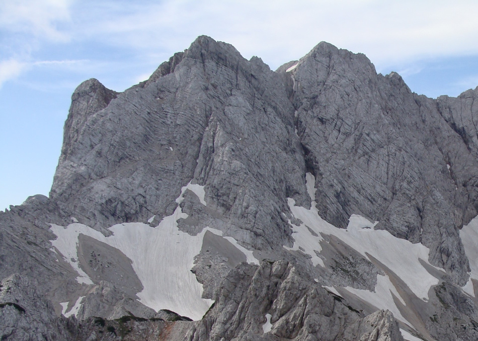
| Skuta (2532 m)
Skuta is the first (or last) peak in the mighty mountainous scenery above Jezersko, which exceeds a height of 2,500m. Due to its exposed position and stunning views, crossing the ridge between Skuta and Dolgi hrbet is one of the most fascinating experiences among the conquest of Jezersko's peaks.
More
|
The Ledenik pod Skuto glacier lies in the basin between Kranjska Rinka
and Skuta, which currently remains the largest glacier in Slovenia.
Along the path you can find another endemic plant of the Kamnik-Savinja
Alps (as is also the case on the other paths on the highest peaks of
Grintovec) – the Zois bellflower.
Trail - From Češka koča hut, Cross the scree at Spodnje and Zgornje Ravni, where the paths split; to Kočna (right) and to the Mlinarsko sedlo saddle, Dolgi hrbet and Grintovec (left), and ascend to the entrance to the southern wall of Grintovec. Follow the secured Frischaufova pot path, constructed way back in 1877, continue to the Mlinarsko sedlo saddle (due to the popularity of this path, in this part a helmet is recommended, and also an ice pick in early summer). From the saddle turn left onto the ridge that leads to the top of Dolgi hrbet. Now follows the most beautiful, though also the most exposed, part of the tour, with constant ascents and descents above the thousand-metre walls of Dolgi hrbet and Trikot. On reaching Štruca, it is just a short walk to the highest point of the tour – the summit of Skuta. The first part of the descent towards Štruca is the same, then, however, you should turn left onto a path which, beneath the already-conquered ridge, leads back to the Mlinarsko sedlo saddle. From here descend to Zgornje Ravni and onwards to the Češka koča hut. (For the approach from the direction of Rinka, look the description for Rinka on this web page). (Source: Jezerska Mountain Path. Guide and diary. PD Jezersko, Jezersko, 2018) (From Češka koča hut)Lenght: 5 km
Ascent time: 4 h Elevation diffrence: 960 m
MApzs map: Skuta
Gpx: Pot
Starting point: parking Turni, parking Ravenska Kočna |
|
|
| Koroška and Kranjska Rinka (2433 m)
Above Ledine, the peaks of Koroška and Kranjska Rinka appear to be making a leap towards the sky. Both are visible from the Jezersko side, whilst Štajerska Rinka is hidden in the background.
More
|
Up to the fall of the Habsburg monarchy this place was the border between three lands of the same name (Carinthia, Carniola, and Styria). The source of the name is not known, the trio of Rinkas (rings) as a symbol of connection, nevertheless it carries a message - that mountains and borders are not places for division but rather for unity. On the meadows above Ledine there are some botanical gems, endemic species of the wider area: nigritella lithopolitanica (Kamnik orchid), leucanthemum lithopolitanicum (Kamnik daisy), aconitium tauricum (monkshood), allium kermesinum (Crimson leek), and others.
Trail - Od Kranjske koča hut on Ledne From the Kranjska koča na Ledinah mountain hut ascend through scrub and across meadows to the Jezersko sedlo saddle, where a path to Koroška Rinka branches off to the right. Continue across scree to the entrance to the wall, then follow the path, equipped with wire ropes and rungs, to the peak of Koroška Rinka (the path is exposed and covered with loose rock, therefore a helmet is mandatory and caution is advised). To continue to Kranjska Rinka follow the path some 10 metres lower and ascend to the neighbouring peak. From here you can either descend or continue ahead on the demanding tour to Skuta and Dolgi hrbet and descend via the Mlinarsko sedlo saddle to the Češka koča hut - in this case descend back to the junction between both Rinkas and then continue down to the fork of the path to Mali podi from where the path ascends to Skuta (see the previous page for a description of the descent from Skuta). (Source: Jezerska Mountain Path. Guide and diary. PD Jezersko, Jezersko, 2018)
(From Kranjska koča hut on Ledinah)
Lenght: 2,7 km
Ascent time: 3 h Starting point: parkrking pod Turni, parking Ravenska Kočna |
|
|
| Kranjska koča hut on Ledine (1700 m)
The Kranjska koča mountain hut stands in a larch forest at the foot of the most southeastern glacier in the Alps, the Ledenik pod Skuto
More
|
In bygone days sheep grazed on the level scree and high mountain meadows above the place where the hut now stands – locally known as Vadine. In the second half of the 20th century, in the summer months there was so much snow beneath the northern wall of Rinka and Skuta that the foot of the glacier was a favourite area for enthusiastic alpine skiers. In 1977 the Kranj Alpine Association erected the hut in order to provide facilities for alpine ski training. A hike to the mountain hut also makes a great standalone tour, is an excellent starting point for demanding rock climbing ascents of the southern walls of Rinka, Skuta, Trikot and Dolgi hrbet. It is also a starting point for tours on the secured paths to Baba, Rinka and Mrzla gora, or for crossing the Jezersko vrh and Savinjsko saddles to Okrešelj in the Logarska dolina valley.
TRAIL - SLOVENSKA POT
From the Ravenska kočna valley walk along the road to the freight cableway. At the sign, follow the marked path for the Slovenska pot (Slovenian route) through the forest to an area of scree beneath the Češka koča hut, towards Žrelo. On the gravel at the end of Žrelo a sign points to the Slovenska pot to the left. The path, with fixed wire ropes, leads over a steep rocky gradient and then along a track through scrub (the path through Žrelo meets here, however, due to the danger of falling rocks it is not advisable to take this path) to the hut. Descend on the easier Lovska pot (Hunters' path) back to the freight cableway and from there along the road back to the start. (Source: Jezerska Mountain Path. Guide and diary. PD Jezersko, Jezersko, 2018)
Lenght: 4,5 km
Ascent time: 2 h
TRAIL THROUGH ŽRELO IS CLOSED !
|
|
|
| Velika Baba (2127 m)
'Baba' in Slovene is another word for an old ugly woman; and Velika Baba is said to be the only Jezersko woman who doesn't speak! It may have got its name due to its shape – seen from the west it looks like a face covered by a scarf.
More
|
Due to its position and north-south alignment, the double peak has a completely unique character and a different logic to conquering it is required than to the other peaks over 2,000 metres in height above the Jezersko valley. Velika Baba is clear of snow quite a bit earlier than the other peaks of the Grintovci mountain chain, therefore a tour to Baba is recommended at times when the northern walls are still/already snow-covered. The entire ridge and the summit lie on the border with Austria, thus offering exceptional views of Carinthia, the northern faces of Grintovci and the Jezersko valley. Trail -From the Planšar Lake (Planšarsko jezero) follow the theme trail to the car park in the Ravenska kočna valley. Turn left in the car park and begin to ascend in the direction of Goli vrh. On the Jenkova planina mountain pasture turn right and continue along the delightful ridge through the old larch forest to Mala Baba. Caution - an exceptionally exposed ridge begins on Mala Baba, where the path follows natural passages and does not have any fixed wire ropes or rungs. The ascent leads ahead to the northeastern peak, from where the path descends slightly and then leads up to the main peak of Velika Baba. Descend across the Jezerski vrh saddle and past the Kranjska koča mountain hut to the valley. Due to the danger of falling rocks, it is not advisable to use the path that leads directly to Ledine across the wall of Ledinski vrh. (Source: Jezerska Mountain Path. Guide and diary. PD Jezersko, Jezersko, 2018)
|
|
|